Welcome to 8850
The Highest Geography On Earth
Starter: Check out both of the videos below. How Hollywood portrays Mount Everest, and how a climber of the mountain might view it!
|
|
|
Task 1 - Which view do you think is more accurate? Would you like to attempt to climb Everest? Why or why not? Write down ten adjectives that you would use to describe Mount Everest from what you have seen in the video.
Task 2 - 2023 - A 70 Year Anniversary of?
2023 was an important year for Mount Everest.
i. Wind the clock back 70 years from 2023, what year would you be in?
ii. Conduct a quick Google search with that year and 'Mount Everest' and find out why and what happened back then.
Task 3 - Now watch the video below from the music group 'Public Service Broadcasting'
|
|
|
Nearly 60 years to the day after the first ascent up Mount Everest, Russian extreme sport star Valery Rozov (48) flew off the north face of Mount Everest - the world's highest BASE jump ever - 7220 meters (23,688ft) above sea level.
Where is Everest & What is it Like?
|
Objective: To find out about the conditions that surround the highest mountain in the world.
*On this map, you will see Tibet, but on other maps all you will see is China.
Click here to find out more about the trouble between China & Tibet. Task 1 - Using both the fact sheet and the map (above), create your own annotated 'Where is Everest & What's it Like' fact sheet. You should include the location of Everest as well as your chosen 10 facts. Use the Google map to the right to help you. Adding an unusual image and caption from Everest will also help to improve the presentation of your work. This would be my chosen image. |
From the Sea Bed to the Top of the World
|
Objective: To find out how and when Mount Everest (a Fold Mountain) was formed and to see if it is getting taller.
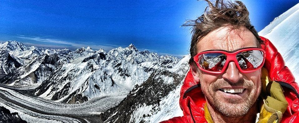
Task 1 - Watch the YouTube video to the right hand side. This is a documentary but you only need to watch up to 11:20. You might find it helpful to make some notes on what you see and hear. Use this worksheet to help you. i. What are the three main layers of rock called that are found on Mount Everest? ii. What were the risks in collecting the samples? iii. What evidence exists to prove that this rock was formed under the oceans? The climber you will see in the video is called Kenton Cool and he holds several Everest records including the one to the right where he sent the first ever tweet from the summit of Everest. You can find out more about him here. Cartoon Strip Task - EVEREST - 50 MILLION YEARS IN THE MAKING. Task 2 - You will be creating a cartoon strip to show the formation of the Himalayas in six stages. You can use the video and the fact sheet (above) to guide you. For the video, the timings of the useful clips are indicated for you. Stage 1 - Continental Drift - India on the Move (15.00 - 16.17) Stage 2 - Crashing & Folding (16.17 - 16.52) Stage 3 - Folding & Thrusting (18.16 - 22:45) Stage 4 - Everest today - Most Famous Mountain in the World (no section on the video for this, draw it in its present state - with plenty of climbers all over it!) Stage 5 - The Growing Quakes (27.30 - 31:30) *Note that he talks about a potential forthcoming earthquake in Nepal* Was he right? Check this out from 2015 (4 years after the documentary was made). Stage 6 - Monsoon & Glaciers - Cutting Everest Down? (31:43 - 38.02) Task 2 - Why does Everest's height keep changing? Watch the Vox video above and right to take notes on why the height of the mountain keeps changing. Task 3 - Time to review your learning. Watch the final 5 minute video above. No notes required, just watch and listen carefully. |
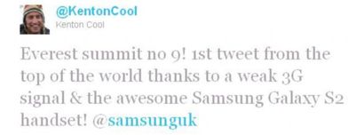
The first ever Tweet sent from the summit of Everest by Kenton Cool

Stage 2 - The formation of the Himalayas caused by the movement of India.
|
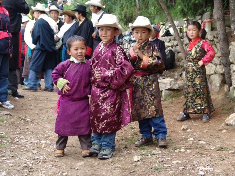
The Sherpa people of Everest
|
|
|
|
Objective: To find out who lives close to Mount Everest and how these people help mountaineers to climb Mount Everest.
Task 1 - Find out about the Sherpa people
Open this worksheet and complete the tasks set out - target 10 minutes. 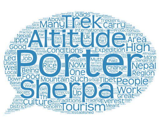
Task 2 - The Sherpa Profile.
You must now read the first fact sheet carefully If you are using PDF, you can use the online highlighter tool (ask your teacher to show you) to show the most important information about the Sherpa. You need to create a person profile (like you find on the back pages of magazines) for the Sherpa. A photo should be in the middle and this should be surrounded by important information to enable the reader to gain as much information as possible about the people* *Hint - most people think that 'Sherpa' is a name given to people who carry the equipment of climbers and have no idea that they are a race of people. 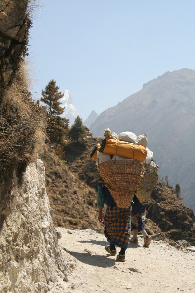
Physical attributes - Think of ...
Strength Ability to operate at high altitudes Work long hours Fit & healthy |
Did you Know?? 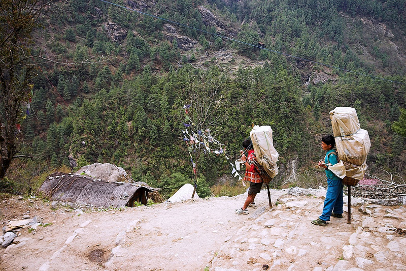
Task 3 - The Hardest Job on Earth?
You must carefully read this article and watch the 'Sherpa Official Trailer' above. Have you ever wondered which Sherpa has the record for the most ascents of Everest? This 6 minute Podcast will give you the answer! Using one PowerPoint slide, create a job advert for a Sherpa Guide on Everest.
You will need to include physical and personal attributes. The mortality (death) rate of a typical Sherpa working on Everest is around 1.2%. That means approximately one out of every 100 Sherpa will die doing their job Personal attributes & skills - Think of...
Languages Communication Attitude towards clients First aid Motivation Climbing Equipment |
Extra Research: Watch the BBC 1 hour documentary on the Sherpa below.
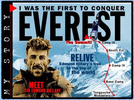
Reaching The Summit Of Everest 1953
Objective: To learn about the first ever people to climb to the summit of Mount Everest and the record their adventure as a series of Instagram posts
|
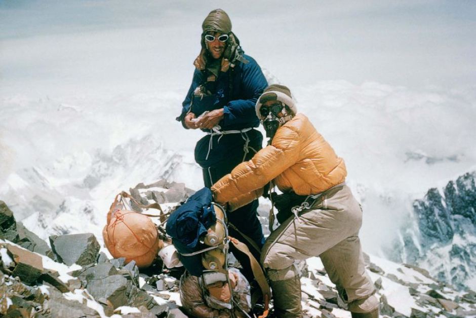
1953 was a big year for Mount Everest. After 50 million years on its own and left alone, at 11.30am on 28th May, two now famous explorers reached the summit of the highest land on earth. Task 1 - Watch the 1950's newsreel YouTube video that records the excitement after the event. Remember, there were no Tweets or Skype calls from the top back in 1953. Task 2 - Download, save and read the fact sheet above carefully. Again, use the PDF highlighter tools to mark out key dates and events. Use this together with the Planning my Instagram worksheet to identify key people, dates and places on this historic expedition. Task 3 - Create an Instagram Feed for either Sir Edmund Hillary or Tenzing Norgay (his Sherpa) about the adventure in 1953. Click the tab above to access the programme. There is a little 'How To' video on the front page to help you to get started. Use your worksheet to think carefully about...
You will need to research both people for their place of birth, date of birth etc using your Google skills. Save your work and be prepared to present your work to the rest of the class. The best examples will be hosted on this website, with your permission. |
|
Altitude Sickness & The Death Zone
|
|
|
|
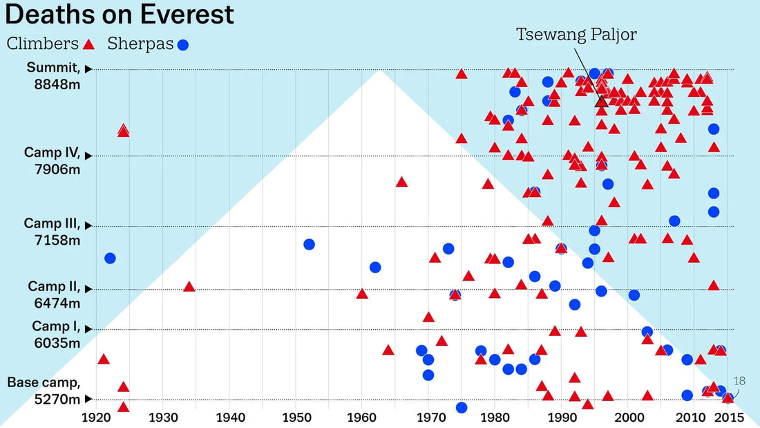
Objective: To find out about the effects of the 'Death Zone' on the human body and the story behind Green Boots.
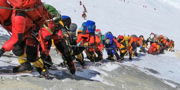
Starter Task - Listen to this 10 minute BBC Witness Podcast. This sets the scene on the fateful day that claimed the lives of many climbers in one terrible storm. The Death Zone relates to any area of a mountain that is above 8000 metres in altitude. Seemingly fit and healthy climbers and mountaineers can suddenly drop dead or start suffering from a number of illnesses above 8000 metres. There is no of knowing how your body will react until you are there. Task 1 - Download and complete the worksheet below Task 2 - The Killer in the Death Zone Open the tab above and read carefully about the effects of altitude sickness on the human body. Using the Primary & Severe symptoms from the Wikipedia list, annotate all of the effects onto your unfortunate climber on this worksheet! Task 3 - How does this look in reality? Then play the first YouTube video at above right - 'Doctors in the Death Zone' between 39.33 and 49:00. Here is an alternative link for the video (start at 46.40) Task 4 - Who was 'Green Boots'?
Green Boots is among many corpses remaining on Everest. Over the years it became a common term, as all the expeditions from the north side encounter the body of the Indian climber curled up in the limestone alcove cave. The cave is located at 27,890 feet (8 500 m), and is littered with spent oxygen bottles. Using the image above right and the information in the Wikipedia article, create a mini fact file on the likely identity of Green Boots and the reason why he was in the same place until 2014 when he mysteriously disappeared and then reappeared and is back in 2018.
|


Greenboots - Died on Everest in 1996 near the summit. Picture taken in 2010.
|
Task 5 - Open the worksheet in the tab below. Complete all the tasks as set out. Check, proof read and print out to hand to your teacher.
Task 6 - Bodies & The Death Zone
i. Recap on what we have learned so far and watch the first video below as a class.
ii. Now, with your headphones one, spend 10 minutes watching and listening to the second video below (What Happens?). Make sure you make notes on why the bodies are left on the mountain, including the different perspectives on why they should not / should be brought down.
Use this worksheet to record your initial thoughts.
|
|
|
|
Task 7 - Your teacher will read this account, taken from a BBC article. Task 8 - Watch and read the resources to the right and below, starting with the National Geographic 360° video and then the 'Cleaning Mount Everest' video followed by the two BBC articles. Add information to your worksheet from Task 6. |
|
|
|
Role Play - The Great Everest Debate
You are going to work on a mini presentation outlining whether the bodies on Everest should be cleaned up, left in their snowy graves or whether the focus should be on the litter and other waste that is causing severe environmental degradation in the Everest area. The Nepalese Government is going to invest several million dollars on a scheme that aims to satisfy the following three objectives:
1. Promote environmental sustainability and better practises on Everest.
2. Keeps the Sherpa happy and honour Everest as a religious symbol.
3. Seeks to honour the memory of those who have died attempting to summit Everest.
1. From the point of view of a group representing relatives of dead climbers in the Death Zone
"Our loved ones are frozen in a place many thousands of KM from home. They died what they loved doing and should be left to rest in peace in the place that they died - a grave that they would have wanted to occupy"
2. From the point of view of the Sherpa people
"Although the bodies are in the Death Zone and very dangerous to remove and bring down, we don't really appreciate our religious icon being littered with bodies".
3. From the point of view the Nepalese Environment Agency
Since Hilary & Norgay summited in 1953, Everest has become a magnet for climbers for all over the world. Given there are no bins and toilets on the mountain, we have a massive problem with waste management, including oxygen cylinders and poo! It is sad that the climbers died and still remain in place, but the biggest concern is the mounting waste issue that needs far more urgent address!
Rules
There will be a debate involving a representative and team from each of the three teams above.
You will have 3 minutes to present your arguments and your plan to satisfy the three objectives stated above. You must have at least 3 PowerPoint slides. You should try to include as much as you have learnt about the mountain up until this point. You should aim to make the strongest argument for the point of view stated above.
You will be judged on your ability to provide a thoughtful and passionate presentation that includes as much Everest Geography, data and Factfulness as possible.
|
Task 9- You will be split into groups of 5. Each of you will be allocated a role from the worksheet above .Your role is very specific on your card. You are to work together to produce an A2 sized presentation for 'Toulouse Trekkers LTD' detailing how you plan to scale the highest mountain in the world. You must all take part in the presentation. You will have 10 minutes per group. |
|
A Diary From The Top Of The World
|
Your mission has been accepted (I hope!) from Orchbury Everest Expeditions Ltd and you have just spent 20 days trekking up to the base camp of Mount Everest (see map to the right). After two days of acclimatization, you are ready to go!
Using the base map on the right as your guide, each member of your team (3-5 members) should create a diary entry detailing the journey to the summit. It is up to you how dramatic your voyage is and whether you all make it or not.
You can use the following tools to help you: 1. The Google Earth Tour - click on blue tab right 2. The Gigapixel Image 3. The Five YouTube videos below |
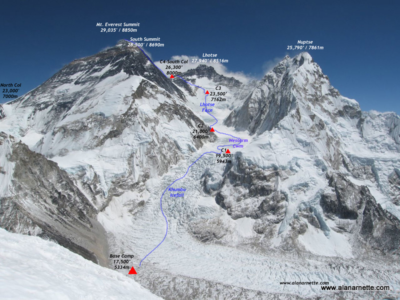
Your planned route up Everest towards the South Summit
|
1. Base Camp - Everest3. Western Cwm (Camp 1 - Camp 2) |
2. Khumba Icefall (Base Camp to Camp 1)4. Lhotse Face (Camp 2 -Camp 3) |
5. The Last Push - Camp 3 to South Col and then to Summit
Everest Written Assessment
Why is Mount Everest so important for Nepal's Economy?
Objective: To produce a written report outlining the importance of continued extreme outdoor tourism to Nepal.
Before we go any further, we need to learn about some economic geography terms. We often hear about rich and poor countries but we do classify them as follows:
LIC =Low Income Country
MIC = Medium Income Country
HIC= High Income Country
We can measure how developed a country is by using a number of development indicators such as:
Task 1 - How developed is Nepal compared to the UK?
We are going to use the UK as a comparison as that is where Kenton Cool is from and he holds the record for the most ascents of Everest by a non-Nepalese climber.
Open and download the worksheet below and complete using the CIA World Factbook website. Links to the website are embedded on the worksheet.
Before we go any further, we need to learn about some economic geography terms. We often hear about rich and poor countries but we do classify them as follows:
LIC =Low Income Country
MIC = Medium Income Country
HIC= High Income Country
We can measure how developed a country is by using a number of development indicators such as:
- Birth Rates
- Death Rates
- Life Expectancy
- GDP Per Capita
- Literacy Rates
Task 1 - How developed is Nepal compared to the UK?
We are going to use the UK as a comparison as that is where Kenton Cool is from and he holds the record for the most ascents of Everest by a non-Nepalese climber.
Open and download the worksheet below and complete using the CIA World Factbook website. Links to the website are embedded on the worksheet.
|
Task 2 - Remind yourself about the Sherpa. Spend 5 minutes watching the first (Everest Tourism Changed Sherpa Lives) and make some notes on who the Sherpa are and what they do and what change has happened. Task 3- What are the impacts on the Sherpa? Check out the first video, 'Disposable Man video to the right. Make notes on the content of the video. Task 4 - What are the environmental risks of too many people on Everest? Check out the third video to the right, and this video too (about cleaning the trash from Everest). Make notes on the content and the rules that are being put in place to control the environmental degradation of the Everest region. Task 5 - Update 2024 - How are Nepal trying to reduce Everest deaths? Watch the video (Electronic Chips Mandatory...) to take notes on how and why the government of Everest is trying to reduce accidents and deaths on the mountain by insisting that climbers wear electronic chips. Make notes on when the rules will start and how the scheme works. Task 6 - You are now ready to start writing up your assessment. See the tab below for full instructions and download the essay template sheet from the blue tab below. |
|
OK, your research is now complete. You are now ready to start writing your report from the notes your have made above.
Don't forget your title:
Why is Mount Everest so important for Nepal's Economy?
Open and download the 'Everest Report Student Mark Sheet' from the tab above. This shows you exactly what you have to do to get the best marks on each section. Your report should be about three - five sides of A4 typed up with images, maps and text.
Don't forget for the location in the introduction, you can use the work you completed for lesson 1 (at the top of this page) to help you.
Good luck.
Thanks to The Royal Geographical Society (RGS) and Jonathan Parrott for resources in this unit of work.