Getting to Know Symbols
Objective: To be able to use and recognise a variety of map symbols and to understand why they are used.
Starter: You are all exposed to a variety of symbols on an everyday basis. Some you see, and many you wear. Complete the 36 question logo quiz* by clicking here. The current champion from Mr Podbury's class scored 33/36
Task 1 - Now, on the back of the starter sheet, you should spend 10 minutes writing a story. The story can be about anything you like, however, there are some new rules. You must try to use as many symbols as possible instead of words. You will be given a partner to work with at the end of the 10 minutes. Your objective is for your partner to be able to retell the full story without hesitating. It could get messy!
* - Answers
|
|
Ok, so now we are moving on to real life maps. Have a good look at any of the maps / globes in the Geography classroom. You will see that they are covered in different colours and different symbols. Check out the symbols for cities, rivers, oceans and mountain ranges. Why don't we just use words?
Task 2 - Watch the video above about map symbols. We are going to be using a map making company called the Ordnance Survey or OS for short. They make super quality maps for many different places around the world. Here is an 18 minute video that explains a little more about the company (not obligatory to watch!).
Task 3 - You will now complete this OS map symbols sheet using the link beneath to help you to draw and complete the symbols as necessary.
You will see that the symbol sheet has 1:50,000 written on the top. This is all to do with scale. In this instance, it means that 1 cm on the map represents 50,000 cm of real space. So, in real life, everything is 50,000 times bigger than on the map!
Resource sheet 1:50,000 Map Symbols Sheet
Resource Sheet 1:25,000 Map Symbols Sheet
Task 4 - - Complete this sheet - Adding Symbols to Maps - following the instructions carefully. Use this template to record your new map on.
Optional Plenary or Starter - Symbols Bingo
Click here for the Bingo sheets and here for the Bingo PowerPoint - thanks to beth2505 (TES)
Exploring OS Map Zone
Mapzone is a brilliant map skills site to visit, with exciting online games, free maps, wallpapers, competitions and a fascinating trivia section, all from Ordnance Survey (the people who make the maps).
During the map skills unit of work and later in your secondary school Geography career, it is a good idea to regularly check back here and try to keep your new found skills up to date.
Check out the homework help section of the map. This will be really useful to you over the course of your work on understanding maps.
Click here to be taken to the site (turn the volume down on your laptop!)
Four Figure Grid References on Maps
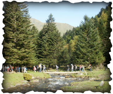
Year 5 & 6 Trip to the Pyrenees
OBJECTIVES - Students should learn how to work out and use 4 figure grid references
Task 1 - Students should watch the video 'Understanding Grid References' at the bottom of this section.
Task 2 - Study this presentation carefully. Teacher may want to use an image and stick in on the IWB to test student understanding of 4 fig references.
Extra - Go here and complete some of the excellent online activities (geographyalltheway.com subscription required)
Task 3 - You will need the OS Explorer Map of Bristol West to complete this activity.
If you don't have the OS stated, you can use the same format to create your own map skills quiz.
Task 4 - Over to you. In a group of three, design a 'Clever OS Map Challenge' consisting of 10 questions similar to the one you have just completed in task 3. You will be using 'Purbeck and South Dorset' or 'Norfolk Coast' Explorer maps.
Here is your research sheet to start your question planning.
Homework - Think you've got it? If so, complete these two worksheet activities.
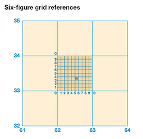
Six Figure Grid References on Maps
Objective - To be able to locate places and features on a map using 6 figure grid references.
Task 1 - Study the grid below and watch carefully how a whole grid can be split up into 10!
Task 2 - Use ActivInspire to overlay an annotation board. Draw on a symbol and ask students to write out the six figure grid reference. Practise a few times and then try it without the 'pretend' grid lines.
Task 3 - Complete the activities on page 101 of Key Geography - Foundations.
Task 4 - Complete this worksheet based on the OS Explorer Map of Norfolk
Plenary Game - Click here to be taken to an interactive game. How many points will you score??
How To Work Out Direction & Distance
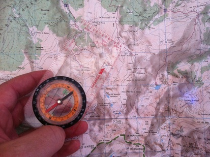
Objective: To be able to use the 4, 8 and even 16 point compass rose and to use a scale line to work out distances between places.
How do we remember the main four points of a compass in order?
North East South West
Never Eat Shredded Wheat .... for example
Task 1 - Can you think of your own? You have 2 minutes to think of a memorable way of remembering the order of the four main points. Then tell us what you did! Complete this worksheet adding the 16 points of the compass rose.
Task 2 - Complete the following worksheet entitled 'Direction in the Park'. This may be projected onto the IWB and the students can copy it out. Extra consolidation work can be completed from page 92-93 of Foundations.
Task 3 - Feeling Confident? Time to use a few of the skills that you have acquired recently. Complete this worksheet mixing Direction, Scale and Symbols.
Scale and Distance
Task 4 - Introduction can be done from the Foundations textbook page 94-95 - Activities 1-5 are particularly good.
Task 5 - Complete this worksheet entitled 'From Sheffield'. Print out a copy of the sheet and answer in the table provided. You will need a good quality ruler for this.
How Is Height Shown On A Map?
Objective: To find out about the three main ways that height can be shown on maps and to create our own Cereal Island.
Starter - Watch the first video underneath - Learn about Contours with Simon King. Task 1 - Turn to page 102-103 of Foundations (or page 32 of the embedded book below). Read the information carefully and then complete this worksheet. Task 2 - Mix of skills. Complete the 'Extras' section at the bottom of page 103 of Foundations book (or activities 1 & 2 from page 33 of the embedded book below). Task 3 - Mix and Match. Complete this worksheet that shows you how to interpret contour lines. When you have finished test yourself with this mini test. How did you do? Task 4 - Donald Trump's Big Day Out! Donald Trump is taking a break from his 2024 election campaign and is hoping to get away from it all and enjoy the countryside in England for a few days (OS Map of Keswick). He has hired you as his personal guide and wants you to plan a 'nice', and 'relaxing' 1 night and 2 day adventure in the countryside. You couldn't possibly want to make this difficult for him would you? Surely, you wouldn't want him to climb up steep slopes and wade through rivers and through dark forests? Complete the worksheet below by clicking on either the PDF or DOC tab. Try to be nice!! ..... not ;-) |

Please don't send me up steep hills !!
|
| |||
| Task 2 Worksheet |
Task 4 - Feeling confident? If so, turn back to page 33 on the document and have a go at completing a cross section from point F to E using the worksheet to the right
| Task 4 worksheet |
|
|
Making a Contour Island
|
Resources
Click here* to be taken to the instructions on how to make your Cereal Island. You target is to make two very different islands. You may choose the ones you like the best. You may need to take your models home to finish. Leave the best one in school so your teacher can show off your creative skills. *This resource was provided by a colleague within the SLN teaching community. Many thanks. |
|
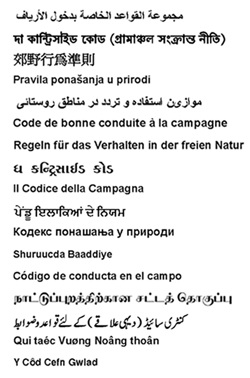
Going Out With Your Map
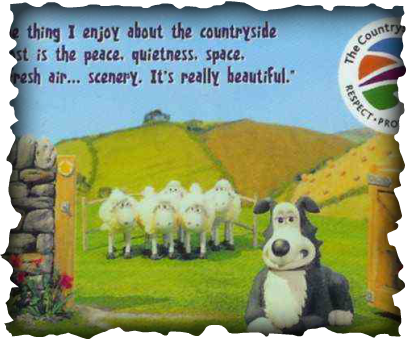
Objective: To understand how to be a responsible user of the countryside.
Task 1 - Watch the countryside code video beneath. What do you like about the video?
Task 2 - Open this document - Going out with your map. Study the images and information carefully and create a display to show people how they should look after their countryside. This can be done in your home language and aimed towards a rural area of your choice e.g. French Pyrenees, English Lake District, German Black Forest etc.
Click here to be taken to an example of a PowerPoint presentation completed by students in Holme School, UK.