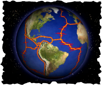
How does the World look like it does today?
Objective: To discover how the surface of planet earth has evolved, and to find out what continental drift means.
Resource 1 - Introductory PowerPoint*
Resource 2 - Plates Puzzle Instructions and Answers
Task 1 - Watch the first YouTube video clip below and ask students for their feedback on what the theme of the film is.
Task 2 - Use resource 1 to introduce tasks to students. Glue and scissors will be needed. Check that the positions of the continents are correct before they are glued down onto the earth outline.
Task 3 - Watch the second video below to see a brief history of continental drift. Enjoy the music!
Play Task - Click on this link. You are going to be taken to an amazing site that links Google Earth with continental drift.
Enter 'Toulouse' (or your home city) into the box in the top left hand corner and you will see a red dot showing where Toulouse is located. Now use the worksheet below, and your copy and paste skills, to complete the activities set out.
|
|
|
How Do Tectonic Plates Move?
Objective: To find out how our earth is structured and how the top layer (crust) works.
Starter: Watch the video - Layers of the Earth - below!
Presentation PowerPoint with questions and images
Teacher Lesson Plan - For this lesson
Task 1 - Complete this worksheet on the structure of the earth. You will need to use this website to help you with task 2.
We are now going to focus on the top layer of the earth - the crust.
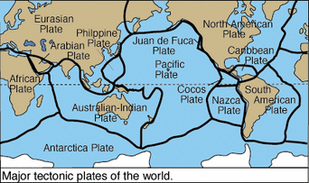
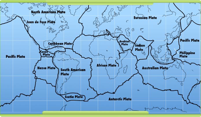
Task 2 - Using the large plate map image below (click to enlarge), complete your plate map worksheet.
This interactive website will help you. Add plate boundaries (black lines) and label the names of the major tectonic plates.
Starter: Watch the video - Layers of the Earth - below!
Presentation PowerPoint with questions and images
Teacher Lesson Plan - For this lesson
Task 1 - Complete this worksheet on the structure of the earth. You will need to use this website to help you with task 2.
We are now going to focus on the top layer of the earth - the crust.
Task 2 - Using the large plate map image below (click to enlarge), complete your plate map worksheet.
This interactive website will help you. Add plate boundaries (black lines) and label the names of the major tectonic plates.
|
|
|
Summary: The Earth consists of four concentric layers: inner core, outer core, mantle and crust. The crust is made up of tectonic plates, which are in constant motion. (source BBC Bitesize)
Task 3 - Watch the video beneath that will re-visit what we have learnt so far and give you some new information on what we will be doing next.
What happens when tectonic plates meet?
Objective: To find out what happens under the ground when two plates meet. To discover the physical features that are created at plate boundaries.
Teacher Resource: Lesson Plan for alternative lesson.
Lesson PowerPoint: (Not my creation but unsure of the innovative source)
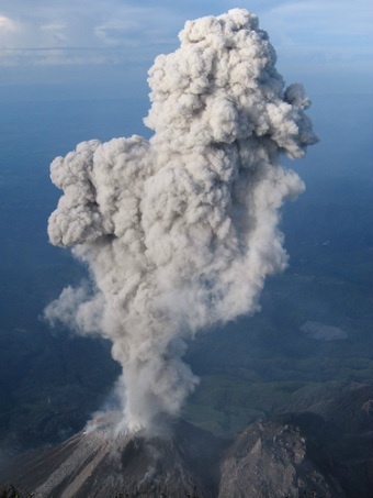
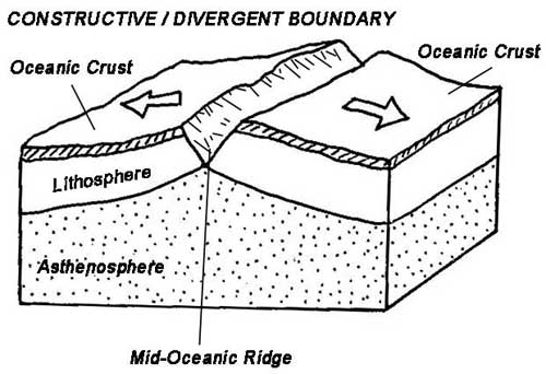
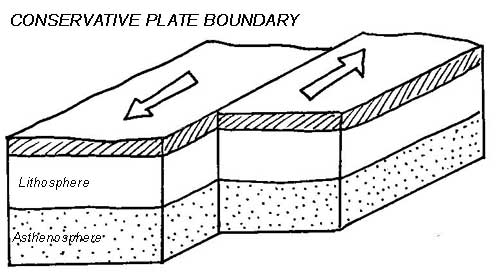
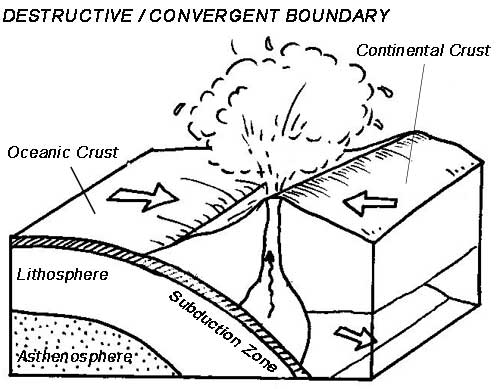
Task 1 - Using this worksheet and the images and text below, copy and paste the correct images and statements into the correct place in the table. Use the clues in the description to help you and your completed A3 size plate maps from last lesson (see above).
Check the work with your teacher and then print out a copy of your sheet for your folder.
Thanks to David Mullarkey from TES for the recording sheet
Teacher Resource: Lesson Plan for alternative lesson.
Lesson PowerPoint: (Not my creation but unsure of the innovative source)
Task 1 - Using this worksheet and the images and text below, copy and paste the correct images and statements into the correct place in the table. Use the clues in the description to help you and your completed A3 size plate maps from last lesson (see above).
Check the work with your teacher and then print out a copy of your sheet for your folder.
Thanks to David Mullarkey from TES for the recording sheet
|
|

|
|
|