
End of year examinations - full revision
|
Hello all. With a few weeks left until the end of year examinations, you will find a bank of revision resources here that will help you to prepare for the big one!
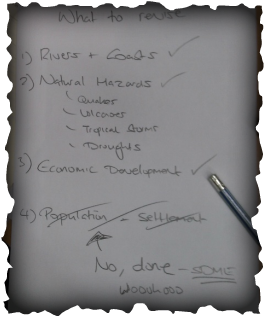
You will find the following items to help you on this page: 1. Knowing your exam paper level and target grade 2. Rivers & Coasts (tested in May 24th 2016 exam in the SDME) 3. Natural Hazards 4. Economic Development 5. Population & Settlement 6. Key Skills 7. Last Minute Tips |

|
Do You Know Your Exam Level & Target Grade?
By now, you will know if you have been entered for the Foundation (F) or the Higher (H) paper. Both papers test the same subject material but the questions are structured in a slightly different way.
|
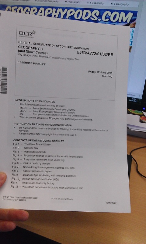
Foundation Paper B563/01
This paper is light yellow in colour (sorry, hasn't come out that well here). It is marked out of 99 and you have 1 hour 45 minutes to complete it. Top mark possible is a GCSE Grade C. Check out the code on the top right hand side. You need to double check this on the day. Make sure that yours says 'F'. |
Higher Paper B563/02
This paper is white in colour unlike the foundation paper. It is marked out of 99 and you have 1 hour 45 minutes to complete it. Top mark possible is an A*. Scores below D grade get a 'U' grade. Check out the code on the top right hand side. You need to double check this on the day. |
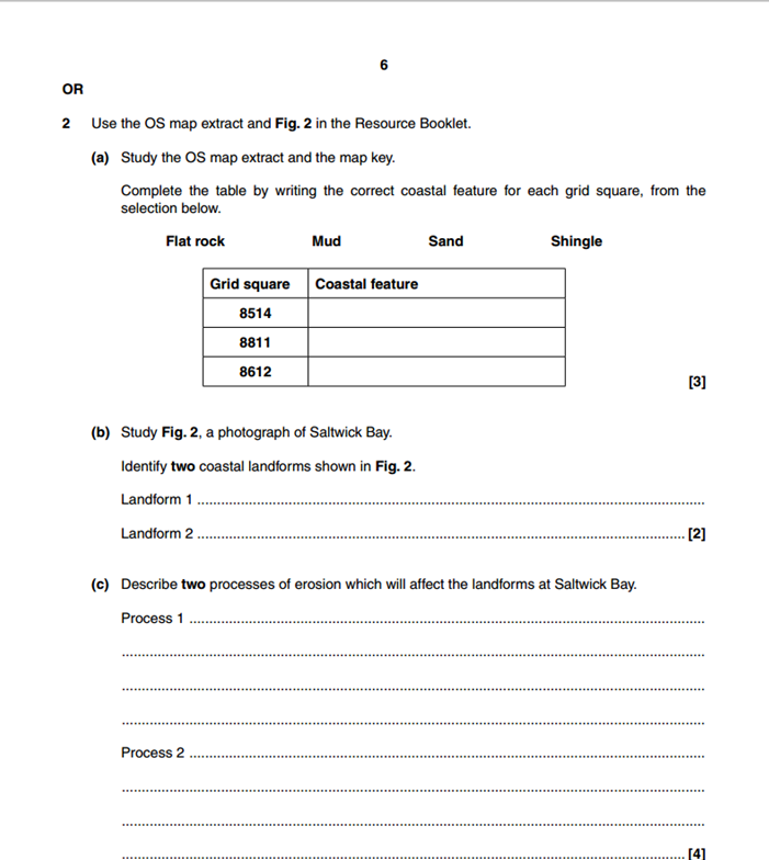
The Foundation (F) paper contains THREE questions on the same topics as the Higher paper but the questions are more structured. You will have to recall all your case studies too. See 'Coasts' example question beneath
|
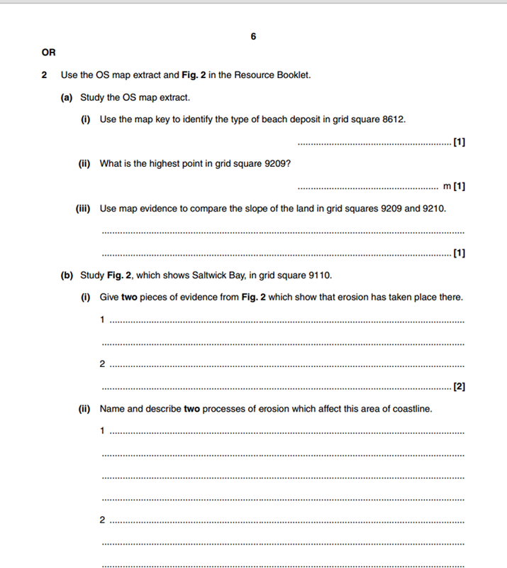
The Higher Paper (H) contains THREE questions that require a higher level of extended writing and application of case studies throughout. See 'Coasts' example question beneath.
|
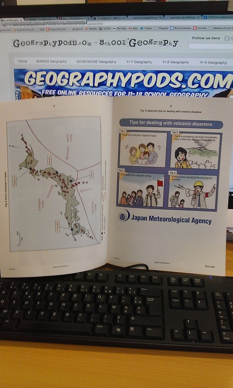
Both the Foundation & Higher papers will be accompanied by exactly the same Resource Booklet. This can be up to 10 pages long and will include graphs, photos, charts, maps and quotes that will relate to questions in the exam paper. Where you need to refer to the Resource Booklet, it will clearly tell you in the exam by stating a figure number e.g. "Study Fig 4, a map showing plate boundaries near Japan".
|
|
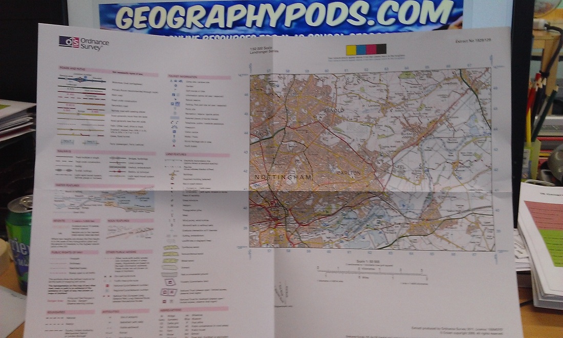
You will also have an OS (Ordnance Survey) Map Extract - See photos below. Your table will be pretty full of stuff, together with your pens, pencils, rulers and rubbers. One question will require the use of the OS map ... and you''ll need to know how to read it too! More on that later.........
WARNING - Read The Small Print!
Every year, one or two GCSE geographers are undone by not reading the small print on the front of their exam paper. Your exam will say the following and it's really important that you fully understand the question structure and what colour to write in. It can mean the difference between success and failure. Look below....
From 2014 onward, there are now marks available for spelling and grammar. Check the instructions above to see where those marks are in the paper. Look of the pencil mark.
Specimen Paper - 2014
Here are the specimen 2014 papers for Foundation & Higher Geography qualification.
Key Geographical Themes Content
|
In 2016, the terminal exam will consist of three questions on the following Key Themes topics:
1. Natural Hazards 2. Economic Development 4. Population & Settlement Rivers & Coasts will be tested but in your SDME. You can use the materials further down on this page to help you with that exam. Check your knowledge of the issues covered using the excellent spreadsheet created by Mr Matthews. Click on the tab to the right. WANT TO BUILD YOUR CASE STUDIES?? - Click here for a tool. |
|
Revision, Revision, Revision. Where To Start?
This is the wonderful screencast produced by Mr Berry for the 2014 paper The three themes under examination that year were Rivers & Coasts, Population & Settlement and Economic Development. This year the SDME covers Rivers & Coasts.
**Note, the structure of the exam and number of marks for each question has changed since 2013** - Consult your teacher to find out what the changes are.
**Note, the structure of the exam and number of marks for each question has changed since 2013** - Consult your teacher to find out what the changes are.
(2016 SDME) Theme 1 - Rivers & Coasts
This theme wil be tested in the SDME examination on 24th May 2016. You need to focus your revision around this type of examination and not the key theme format.
Click here for an exellent mock examination based on the Rivers & Coasts theme and created by Leventhorpe Geography Department
Click here for an excellent revision & case study list for the Rivers & Coasts unit. This was completed by Mr Briggs but remember that not all schools do exactly the same case studies. This is a great starting point though.
i. Coasts
Your first task is to watch and listen to the following screen cast beneath by the Geography legend that is Mr Berry. Get ready for Bob the Builder & The Daleks!! **Listen to the theory & case study but the number of marks allocated and the time for each question has now changed so ignore that**
|
The most likely scenario here is that you will have a mixture of both rivers and coasts questions in this section. Be prepared for all eventualities.
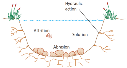
You will need to know the following: Processes of Erosion (hydraulic action, attrition, solution & abrasion) - Click here for further explanation, videos etc. Each of these processes contributes to the erosion of the coastline and the production of some special features (so below) Types of Waves Don't forget you can have constructive & destructive waves. As the wave moves up the beach, it is called swash. As it rolls back down the beach, the movement is called backwash. Watch Mr Rogers video to the right for a really great example. Erosional Features Don't forget to revise your erosional features. You could be asked to explain the formation of the following features: (see Wales video)
* A hard rock feature - Slower erosion **A soft rock feature** - Faster erosion Make sure that you can describe how one feature can lead on to another e.g. "The sea exploits a weakness in the cliff face, where less resistant rock lies, and begins to open it up by the processes of hydraulic action and attrition. This is a faster process on exposed coastline and the weakness is eventually opened up into a cave ...... etc" You get the idea? Or............ Where bands of hard and soft rock (geology) lie parallel to the coastline, the sea will often exploit a weakness in the harder rock via the four processes of erosion. Once through, it erodes quickly into the layer of soft rock behind Making links between erosional processes and the landforms is really important. You need to know your stuff. Processes of Transportation Material is moved along the beach by a process called Longshore drift. Waves hit the beach (swash) at a right angles, driven by the prevailing wind. The backwash runs straight down the beach dragging beach material with it. Again, watch the excellent Mr Rogers video above to the right. Check this BBC animation to make sure you understand what's going on. Got it? Study the photo to the right hand side. Which way is longshore drift occurring? (left to right or right to left) Draw a 60 second diagram to show how longshore drift occurs along the beach. Don't forget to name and add key processes annotations to the diagram. Depositional Features Deposition occurs when materials are moved and then left in situ. Examples features are: 1. Beaches 2. Spits Got it? Study the diagram to the right and watch the West Wales Spits video to the right. Q. How does the process of Longshore Drift lead to Spit formation? Use a diagram to help you to explain. Q. Explain what happens to the area behind the spit and the original shoreline. Q. Would a spit ever traverse and block a tidal estuary completely? Find your case study example of a spit and read up carefully about its location and main features. A great example is Spurn Head. Do a Google search for more information. |

Got it? (8 minute task)
Make a sketch of Lulworth Cove, above. Annotate five features and processes that have led to its formation. 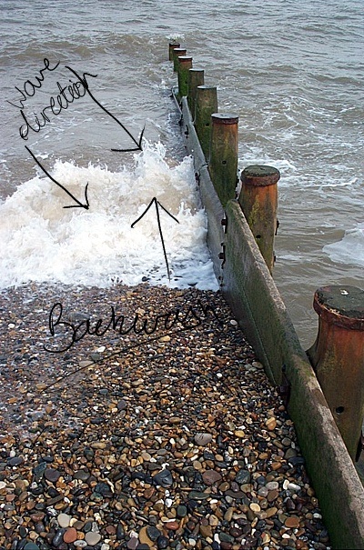
Source: Daniel Masciantonio's Blog

|
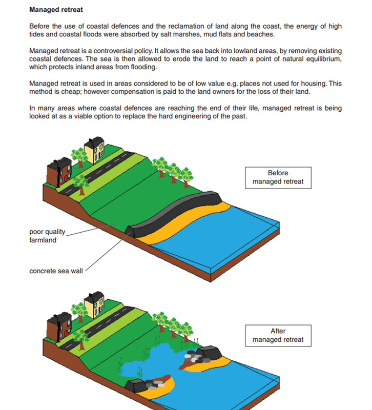
Coastal Protection Methods
|
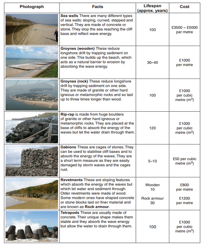
Study the information to the right hand side. This is taken from the June 2011 OCR SDME on coastal protection. It gives you some great information on the different types of sea defences, their approximate lifespan (how long they will last for) and the cost. These methods are classed as HARD ENGINEERING.
Don't forget that a cost-benefit analysis is always required before deciding on whether to protect a stretch of coastline. If the land behind it is expensive (i.e. expensive property, business, industry, communications etc), then money will be spent accordingly. You wouldn't build a 50 metre stretch of sea wall costing £250,000 to protect a house worth £100,000. STOP CHECK: Can you identify how each type of protection actually works? Which ones stop erosion? Which stop transportation (LSD)? |
|
SOFT ENGINEERING can also take place. There are a number of ways shown in the two images beneath.
**Click on the images to enlarge**
**Click on the images to enlarge**

Who does coastal erosion concern?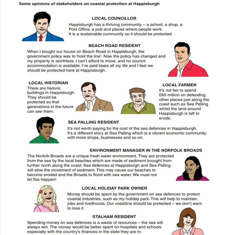

|
20 minute timed examination question.
Try your skills with the following two questions 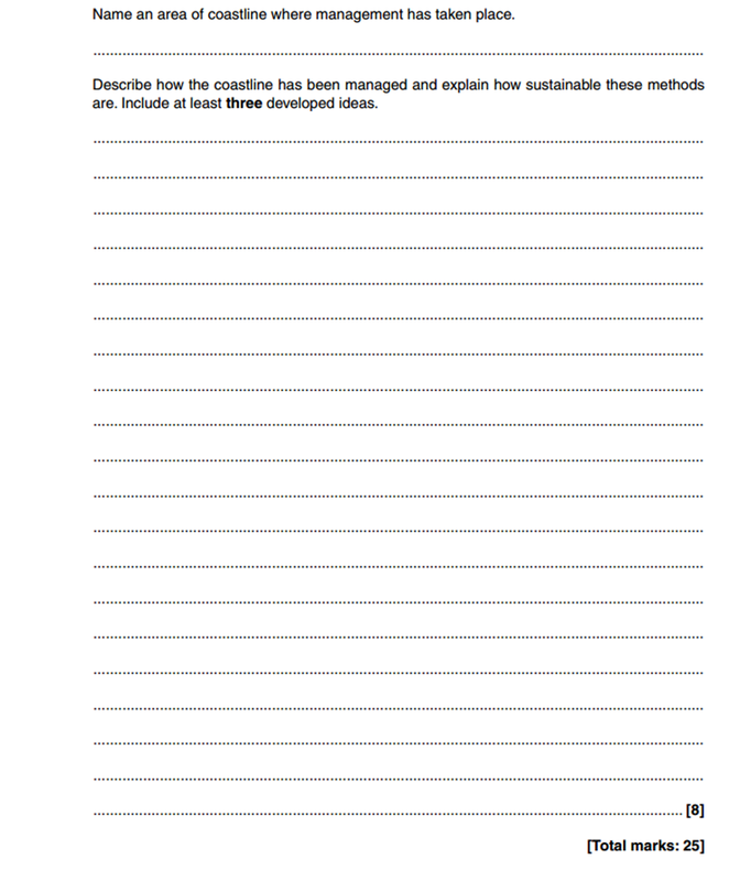
|
Coasts- Exam Practice
After watching the Podcast and videos above, have a go at the following BBC Bitesize tests. At this point, together with the work you have done in school, you should be fairly confident.
1. Coastal Processes
2. Erosional Landforms
3. Depositional Landforms
4. Coastal Management
5. Coastal Flooding
Below is the link to previous OCR B questions on Coasts and the resource booklet that goes with them. Use your geographical skills, case study understanding and theory knowledge to answer them.
Open either the June 2011 Higher or Foundation Paper Below and scroll to page 6-8. Open the June 2011 Resource Booklet and scroll to page 3.
Complete question 2 - worth 25 marks. Target time is 30 minutes.
ii. Rivers
Your first task is to watch and listen to the following screen cast beneath by the Geography legend that is Mr Berry. **Listen to the theory & case study but the number of marks allocated and the time for each question has now changed so ignore that**
The following work is taken from Greenfield Geography and is courtesy of Mr Daniel Greenfield - Creative Commons Attribution Non-Commercial 3.0 License
|
Features of a river - PDF Explanation & case study sheet using the River Tees, England.
A good starting point is to watch the first 19 minutes of the first video to the right. This is the same series as the coasts video and presented by Elliot Brown. During the video, you will see all the main features and processes in the rivers unit of work. 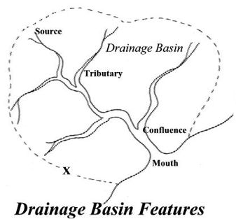
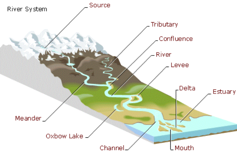
Source: The start of the river, normally found in mountainous areas.
Mouth: The end of the river, this is normally where a river enters the sea, but it can be where it enters a lake. Tributary: A small river that flows into a bigger river Confluence: Where two rivers join/meet. Estuary: The section of the river near the mouth that is tidal. Drainage basin (catchment area): The area of land that drains into one river and its tributaries. A drainage basin is known as an open system because water can be added and lost. Watershed: The dividing line between two drainage basins. Types of ErosionErosion: the process of wearing something away. The river erodes in four main ways; attrition, corrosion, corrasion and hydraulic action.
Corrasion (abrasion): The process of a rivers' load crashing and rubbing into a rivers' banks and bed causing pieces to break off. Corrosion (solution): The process of water dissolving a rivers' load as well as its bed and banks. Hydraulic action: Water and air getting into cracks in a rivers banks and bed causing erosion through increased pressure. Attrition: Load crashing into each other in a river. This normally happens with suspended load. Remember in the upper course near the source there is more vertical erosionand in the lower course near the mouth, there is more horizontal (lateral) erosion. This is because near the source a rivers' load is bigger and more angular and therefore less likely to be suspended in a rivers flow. Instead it will bounce and crash into the bed, causing vertical erosion. However, nearer the mouth load is smaller and smoother and therefore more likely to be suspended and therefore more likely to crash in the banks, causing horizontal erosion. Because of erosion a rivers' load tends to get smaller and smoother as you move from the source to the mouth. |
River Profile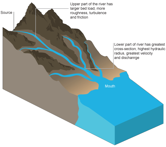
River Long Profile: The long profile is the course the river takes from its source to its mouth. The long profile is often split into upper course and lower course (and sometimes middle course as well). The upper course is near the source and is normally found in mountainous areas. The lower course is near the mouth and on much flatter ground nearer sea level. Some rivers may have their mouth in lakes or wetland areas e.g. the Okovanga in Botswana, but this is unusual.
|
River Landforms
|
River landforms can be categorised in two different ways. They can be classified either by the processes that made them (erosion, deposition, erosion and deposition) or where they are found (upper course, middle course or lower course)
Upper Course
|
EROSIONAL LANDFORMS
|
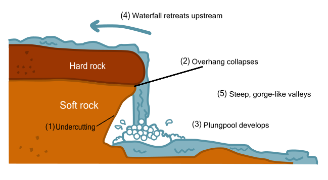
Waterfall: Waterfalls are where water descends vertically. Waterfalls are usually created by a change in rock type. As the river moves from hard rock to soft rock, erosion increases creating a waterfall.
As the water falls over the waterfall it erodes the river bed and the bottom of the waterfall. This makes a plunge pool and causes some undercutting. The undercutting creates an overhang which will eventually become too heavy to be supported and collapse into the plunge pool. The whole process then starts again, which means the waterfall is constantly retreating upstream towards the source. As the waterfall retreats it leaves behind a gorge.
Gorge: A gorge is a deep sided valley left behind when a waterfall retreats.
Rapids - Rapids are sections of rough turbulent (white water) water. They are normally in a river's upper course and are formed when you get layers of hard and soft rock. The layers of soft rock erode quicker than the layers of hard rock. This makes the bed of the river uneven creating rough turbulent water.

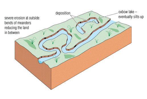
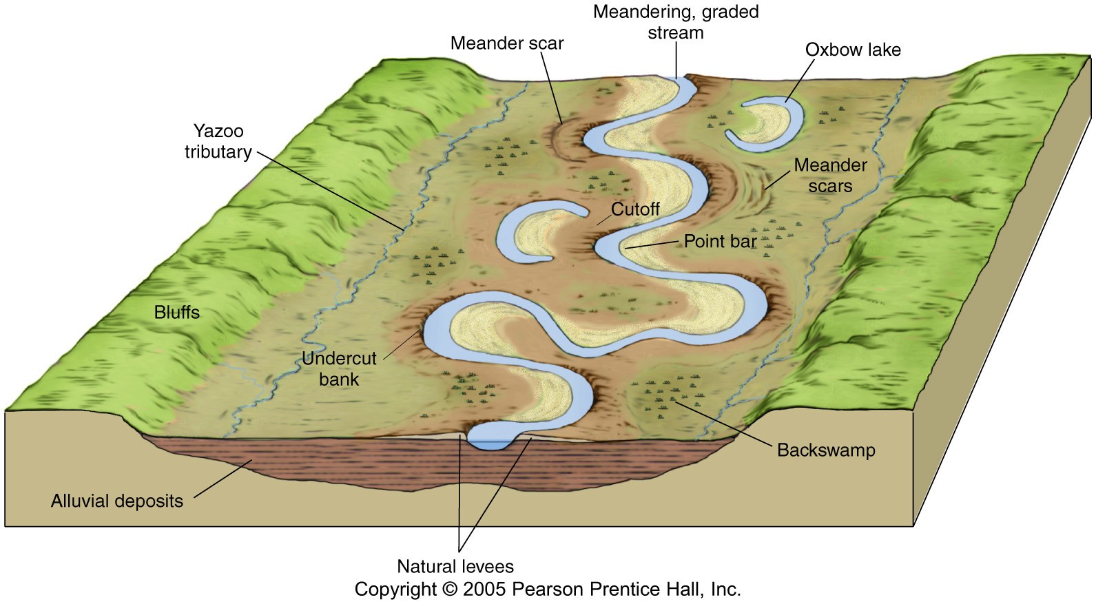
Meanders: A meander is simply a bend in the river. If a river is very bendy it is said to be sinuous. A meander starts to form when the thalweg moves to one side of the river channel. This causes greater erosion on one side of the channel and deposition on the other. Over time the erosion and deposition will cause the river to bend. Meanders are constantly moving and over long periods of time widen the floodplain.
Slip-off slope (point bar): This is formed on the side of the river with greatest deposition (the inside of the meander). It is simply deposited material that forms a small beach like area and gently sloping bank. River cliff: This happens on the side of the river channel with greatest erosion (the outside of the meander). It creates a steep sided bank which often leads to undercutting of the bank. |
V-shaped Valley and Interlocking Spurs
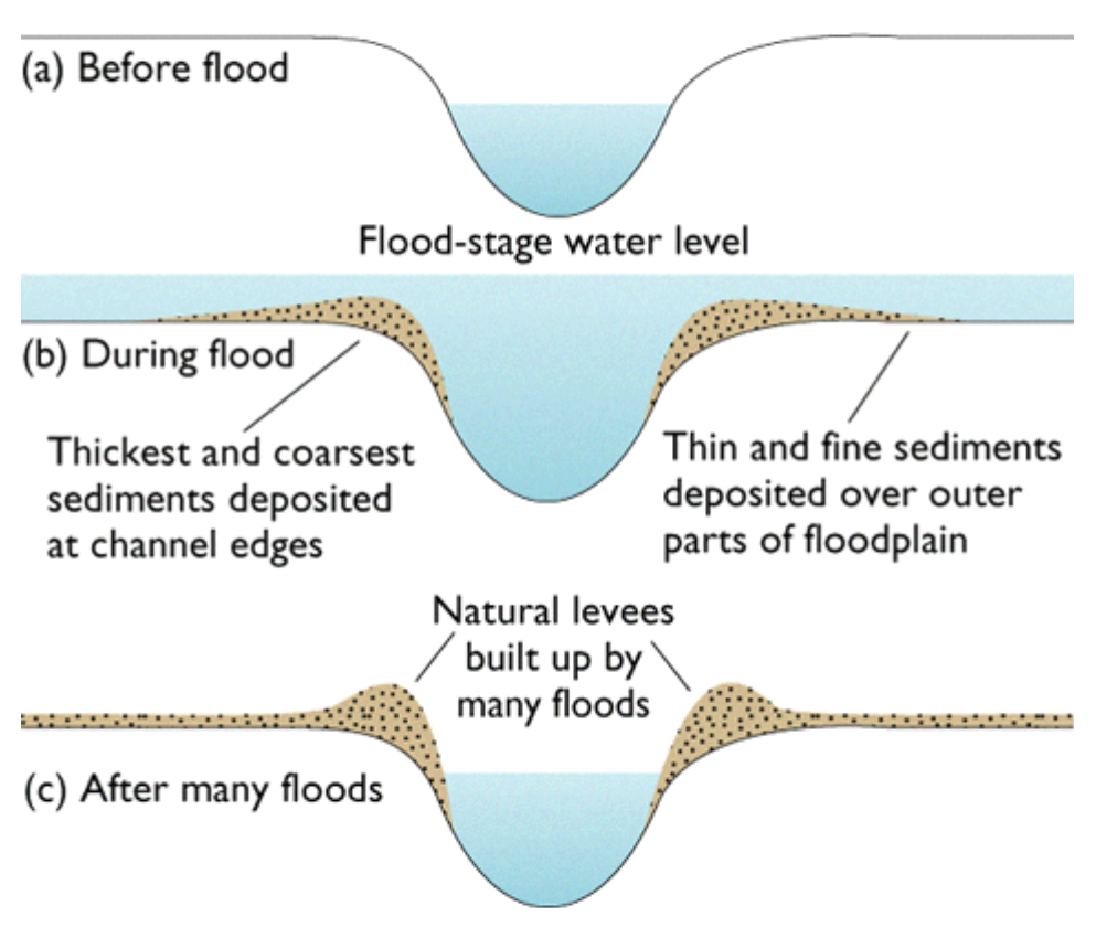
V-shaped valleys are found in a river's upper course where vertical erosion is dominant. The river will erode (cut) downwards while the sides are weathered (attacked by the weather e.g. rain, wind and the sun). The weathered material will then fall into the river and be transported away leaving a v-shaped valley. Interlocking spurs are the areas of the valley (hills) that stick out into the river forcing it to meander around them. Levees: Levees can be natural or man-made. They form on the edge of the river channel. When a river floods the velocity of the river travelling over the flooded floodplain suddenly falls. Because of the fall in velocity (and subsequent reduction in surplus energy) the river immediately deposits its largest load creating embankments that line the river channel. Over time (and after many flood events) these embankments begin to grow in size and become more stable. These are sometimes strengthened by humans or completely made by humans to try and reduce flooding. 
|
Oxbow lakes: Oxbow lakes are created when two meanders connect (join). The river will often finally connect the two meanders during a flood event when the river is more powerful.The current then shifts to the centre of the river (and does not travel around the old meander) causing deposition on the outside of the river channel cutting off the old meander and creating an oxbow lake.
Click to enlarge
|
Floodplain: Floodplains are simply the areas of land that rivers flood onto when they exceed bankfull discharge. Floodplains are created by the constant movement of meanders. Because horizontal erosion is more dominant in a rivers lower course, floodplains tend to be a lot wider in a river's lower course. If you live on a floodplain you are at risk of being flooded. However, they also make great farmland because of alluvial deposits.
Alluvium: Mineral rich load that is deposited on floodplains in times of flood. Alluvium is essential to keep farmland fertile |
Flood Protection Techniques
A flood is a when a river exceeds its bankfull discharge and floods onto its floodplain. There are numerous techniques that are used to try and reduce flooding. The techniques can be roughly divided into hard and soft engineering.
Hard engineering: This is building physical and permanent structures usually out of concrete and/or metal. Hard engineering solutions are usually more expensive, often ugly to look at, but can be very effective at preventing floods.
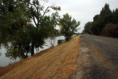
Levees are embankments built next to the river channel. The simple idea of levees is to increase the cross-sectional area of the river channel. This means that the river channel is able to hold more water before reaching bankfull discharge and are therefore less likely to flood.
|
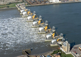
Flood barriers are very expensive to build so therefore are only used to protect important urban areas. Flood barriers when closed form a physical barrier across the river channel. The flood barrier below is in London and is actually designed to stop storm surges flowing up the river from the sea.
|
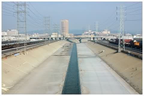
Flood control channels are concrete channels that normally contain no water. They may run above or below the surface and only get used when the normal river is about to reach bankfull discharge. If a river is about to reach bankfull discharge then water will be diverted into the flood control channel.
|
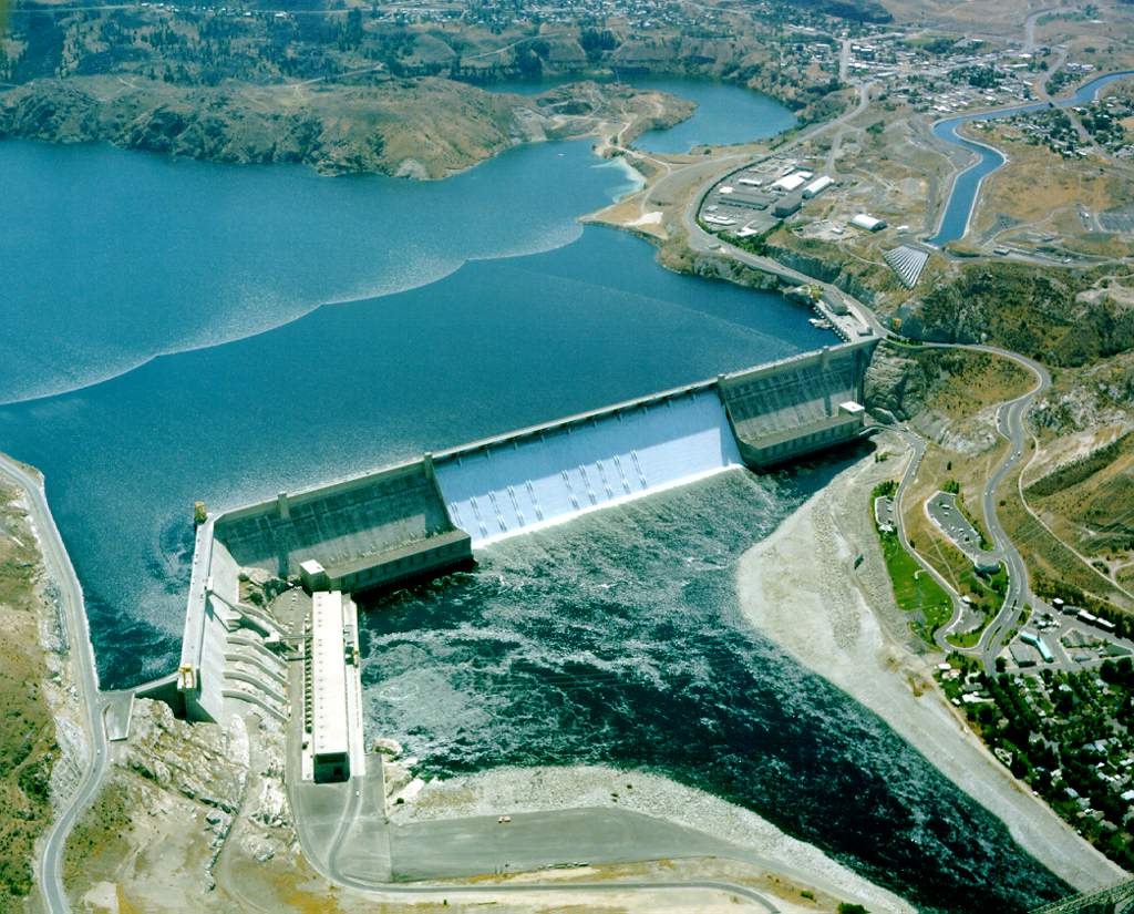
Dams are probably the most recognisable of all flood defences and one of the most expensive to build. Dams often have multiple purposes, but one of those purposes is to regulate a river's flow so that the river never exceeds bankfull discharge.
|
Soft engineering: This working with nature to reduce flooding. Soft engineering solutions can be cheaper and less visually intrusive.
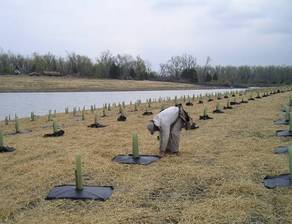
Reforestation or afforestation is simply planting trees. Trees can be planted anywhere in a river's floodplain. The purpose of planting trees is to try and increase the lag time (the period of time between peak rainfall and peak discharge) of a river. Trees increase the lag time by intercepting precipitation and slowing its movement to rivers. By slowing the movement of water to the river means it will experience smaller peaks in discharge.
|

Controlled Flooding as the name suggests, it is allowing a river to flood. However, instead of letting the river flood anywhere a river is allowed to flood on land with low economic value. This means that area of farmland maybe allowed to be flooded in order to protect more important land uses like settlements and sites of industry.
|
MEDC Flood Event - Boscastle UK
Boscastle is located in the county of Cornwall which is situated in the SW of the UK. Boscastle is a small village that only had 888 residents in 2001. A flash flood occurred on the Valency River in Boscastle on the 16th August 2004. The flood was extremely severe and was a 1 in 400 year event. Despite the devastating nature of the flood there was amazingly no deaths or serious injuries. This was largely due to the rescue efforts of 7 helicopters who airlifted 150 people to safety.
However, about 100 cars, 5 caravans, 6 buildings and several boats were washed into the sea; approximately 100 homes and businesses were destroyed; trees were uprooted and debris was scattered over a large area.
PHYSICAL CAUSES OF BOSCASTLE FLOOD
HUMAN CAUSES OF BOSCASTLE FLOOD
However, about 100 cars, 5 caravans, 6 buildings and several boats were washed into the sea; approximately 100 homes and businesses were destroyed; trees were uprooted and debris was scattered over a large area.
PHYSICAL CAUSES OF BOSCASTLE FLOOD
- The Valency valley has a very steep gradient
- The steep valley sides caused very quick surface run-off
- The ground around the river was saturated. The saturation was caused by heavy rain leading up the 16th August
- The weather on the 16th August was extremely hot, causing convectional rainfall
- Over 12cm of rain fell in a couple of hours
- The narrow valley, small river channel and fast surface run-off caused the river to reach bankfull discharge very quickly
- Much of the valley rock is impermeable
HUMAN CAUSES OF BOSCASTLE FLOOD
- There were no flood barriers in Boscastle
- The sewer and drainage system in Boscastle were very old so they became full very quickly
- A bridge in the centre of Boscastle caused material to get stuck behind. This caused a temporary dam causing the river to flood around the village
- Boscastle was built in a narrow valley next to a river.
- Residents had never experienced a major flood event so were unprepared.
- Although Boscastle is only a small urban area, urbanisation can contribute to flooding. Urbanisation creates impermeable surfaces which stops infiltration and increases surface run-off into rivers.
|
Rebuilding Efforts after the 2004 Boscastle Flood
Since the 2004 flood, many things have been done to reduce the chance of flooding in the future. Some of the major improvements are: 2004
|
Study the screencast from Mr Berry below. **Listen to the theory & case study but the number of marks allocated and the time for each question has now changed so ignore that**
LEDC Flood Event - Bangladesh
|
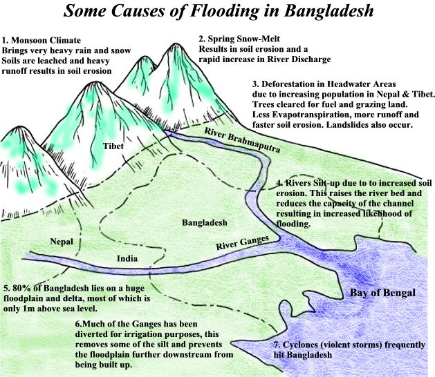
Bangladesh: Bangladesh is located in South Asia. On three sides it is surrounded by India and on the fourth is the Bay of Bengal. Bangladesh has a population of 156 million people, a population density of 1099 square kilometres and a GDP per capita of only $1900.
Because of various human and physical factors, Bangladesh regularly suffers from floods. Below are some of the main causes: Human Causes
Physical Causes
|
The Effects of the 1998 Flood
|
**Listen to the theory & case study but the number of marks allocated and the time for each question has now changed so ignore that**
Rivers - Exam Practice
After watching the Podcast and videos above, have a go at the following BBC Bitesize tests. At this point, together with the work you have done in school, you should be fairly confident.
1. Background to Rivers
2. River Processes
3. River Landforms
4. River Flooding & Management
5. Water Usage
Below is the link to previous OCR B questions on tectonic hazards and the resource booklet that goes with them. Use your geographical skills, case study understanding and theory knowledge to answer them.
Open either the June 2011 Higher or Foundation Paper Below and scroll to page 2-5. Open the June 2011 Resource Booklet and scroll to page 2. The map extract from the examination is not available online due to copyright restrictions, however you can find it by clicking on the last tab and zooming in to Whitby.
Complete question 1 - worth 25 marks. Target time is 30 minutes.
Theme 2 - Natural Hazards
This unit is broadly split into two parts. Firstly Tectonic Hazards (Earthquakes, Tsunami & Volcanoes) and then Climatic Hazards (tropical storms and droughts)
In the exam you should expect this section of the paper to contain questions on all of these hazards and so you should be prepared for them all, including your case studies.
Click here for an excellent revision & case study list for the Natural Hazards unit. This was completed by Mr Briggs but remember that not all schools do exactly the same case studies. This is a great starting point though. Click here for a revision sheet from Villiers school, UK.
Click here for an A3 four page revision sheet created by geographypods for his students at the International School of Toulouse.
At the International School of Toulouse our case studies were:
Earthquake LEDC - Haiti 2010 (see Podcast below)
Earthquake MEDC - USA 1994
Volcano LEDC - Nevado Del Ruiz, Mexico 1985
Volcano MEDC - Mount Etna, Italy Constantly erupting
For each case study, you need to know
CAUSES, SHORT TERM EFFECTS, LONG TERM EFFECTS, SHORT TERM RESPONSES, LONG TERM RESPONSES ... AND HOW THEY VARY BETWEEN COUNTRIES OF DIFFERENT LEVEL OF DEVELOPMENT. HOW CAN THE HAZARD BE MANAGED, PREDICTED OR EVEN PREVENTED?
Part 1 - Tectonic Hazards
Over in Devon, UK, Mr Berry has been at it again and produced this most excellent revision Podcast on the tectonic hazards section of this unit. Tectonic refers to earthquakes, volcanoes and fold mountains. Spend 17 minutes watching and listening to the Podcast below and taking notes, practising your diagrams in anticipation of some of the sample OCR B questions below. **Listen to the theory & case study but the number of marks allocated and the time for each question has now changed so ignore that**
|
|
|
Tectonic Hazards - Exam Practice
After watching the Podcast and videos above, have a go at the following BBC Bitesize tests. At this point, together with the work you have done in school, you should be fairly confident.
1. Plate Tectonics
2. Earthquakes
3. Volcanoes
4. Managing Tectonic Hazards
Below is the link to previous OCR B questions on tectonic hazards and the resource booklet that goes with them. Use your geographical skills, case study understanding and theory knowledge to answer them.
Open the June 2012 Paper Below and scroll to page 11-13. Open the June 2012 Resource Booklet and scroll to page 10-11.
Complete question 4 - worth 25 marks. Target time is 30 minutes.
Part 2 - Climatic Hazards
So, as you know, this section will be on either Tropical Storms (also called Hurricanes in the Atlantic & Typhoons in the Indian Ocean) or droughts, or maybe a mixture of both. Be prepared.
At the International School of Toulouse our case studies were:
Tropical Storm LEDC - Typhoon Nargis, Burma 2008 (see Podcast below)
Tropical Storm MEDC - Hurricane Katrina, USA 2005 (see Podcast below)
Drought LEDC - Horn of Africa 1985 onwards*
Drought MEDC - Australia until 2012*
For each case study, you need to know
CAUSES, SHORT TERM EFFECTS, LONG TERM EFFECTS, SHORT TERM RESPONSES, LONG TERM RESPONSES ... AND HOW THEY VARY BETWEEN COUNTRIES OF DIFFERENT LEVEL OF DEVELOPMENT HOW CAN THE HAZARD BE MANAGED, PREDICTED OR EVEN PREVENTED?
*Both from the orange OCR B textbook. You have a digital copy on your laptops.
Time to cross over to Mr Berry for a few words of wisdom. He's fast becoming the Geography teacher that you've known all your life!! **Listen to the theory & case study but the number of marks allocated and the time for each question has now changed so ignore that**
Climatic Hazards - Exam Practice
After watching the Podcast above, click here to take the brief BBC Bitesize test.
Above (as per last exam practice) is the link to previous OCR B questions on climatic hazards and the resource booklet that goes with them. Use your geographical skills, case study understanding and theory knowledge to answer them.
Open either the Higher or Foundation June 2012 Paper Below and scroll to page 8-10. Open the June 2012 Resource Booklet (same for both Higher & Foundation) and scroll to page 8-9.
Complete question 3 - worth 25 marks. Target time is 30 minutes.
**Listen to the theory & case study in the screencasts below but the number of marks allocated and the time for each question has now changed so ignore that**
Theme 3 - Economic Development
This is the strange unit that is not so simple to split up like 'Rivers and Coasts' or 'Earthquakes & Volcanoes' and is the one that most GCSE students find the most difficult to revise for in terms of case studies and what you need to know. The best way to split the unit up is as follows:
1. Development & Aid
2. Industry & Trade
At the International School of Toulouse, we used the following:
Click here for an excellent revision & case study list for the Economic Development unit. This was completed by Mr Briggs but remember that not all schools do exactly the same case studies. This is a thorough and detailed starting point though.
Part 1 - Development & Aid
Back to Mr Berry and the first of two revision Podcasts on the Economic Development unit. This one deals with the concepts of development and aid. Then to Mr Lowry's two Keynote's below that. Off you go...... **Listen to the theory & case study but the number of marks allocated and the time for each question has now changed so ignore that**
1. Development & Aid
2. Industry & Trade
At the International School of Toulouse, we used the following:
- LEDC Aid Project - Either Goat or Computer Aid
- Primary Industry - Flowers in Kenya
- Secondary Industry - Nike Debate
- Tertiary Industry - Call Centres in India
- Quaternary Industry - M4 Corridor, England
- Multinational Companies - Nike Debate
- Economic Development & Pollution - Pearl Delta, China.
Click here for an excellent revision & case study list for the Economic Development unit. This was completed by Mr Briggs but remember that not all schools do exactly the same case studies. This is a thorough and detailed starting point though.
Part 1 - Development & Aid
Back to Mr Berry and the first of two revision Podcasts on the Economic Development unit. This one deals with the concepts of development and aid. Then to Mr Lowry's two Keynote's below that. Off you go...... **Listen to the theory & case study but the number of marks allocated and the time for each question has now changed so ignore that**
|
|
|
Development & Aid - Revision Sheets
Best at A3 size
|
|
|
Development & Aid Exam Practice
After watching the Podcast and studying the Kingdown slideshow above, have a go at these BBC Bitesize tests:
1. Development
2. Factors Influencing Development
3. Uneven Development
4. Aid
Below is the link to previous OCR B questions on Development & Aid and the resource booklet that goes with them. Use your geographical skills, case study understanding and theory knowledge to answer them.
Open either the Higher or Foundation June 2012 Paper Below and scroll to page 14-16. Open the June 2012 Resource Booklet (same for both Higher & Foundation) and scroll to page 12-13.
Complete question 5 - worth 25 marks. Target time is 30 minutes.
Part 2 - Industry & Trade
OK, you know the drill by now. First up, Mr Berry and his final Podcast in the 2014 series on Industry & Trade and then a Keynote YouTube by Mr Lowry underneath. **Listen to the theory & case study but the number of marks allocated and the time for each question has now changed so ignore that**
OK, you know the drill by now. First up, Mr Berry and his final Podcast in the 2014 series on Industry & Trade and then a Keynote YouTube by Mr Lowry underneath. **Listen to the theory & case study but the number of marks allocated and the time for each question has now changed so ignore that**
Industry & Trade Revision Sheets
Best at A3 Size
|
|
|
Trade & Industry Exam Practice
After watching the Podcast, have a go at these BBC Bitesize tests:
1. Trade
2. Characteristics of Industry
3. Industry in MEDC's
4. Industrial Change in MEDC's
5. Greenhouse Effect
Above (as per last practice exam) is the link to previous OCR B questions on Industry & Trade and the resource booklet that goes with them. Use your geographical skills, case study understanding and theory knowledge to answer them.
Open the June 2012 Paper Below and scroll to page 17-19. Open the June 2012 Resource Booklet and scroll to page 14-16.
Complete question 6 - worth 25 marks. Target time is 30 minutes.
Theme 4 - Population & Settlement
Important & Don't Forget - Key Skills
|
One of the questions in the May 2014 exam will require you to use some OS map skills to answer the question.
The map extract will look like this one and be separate to your exam paper and resource booklet. What you need to be able to do: a. 4 figure grid references b. 6 figure grid references c. recognise contour patterns and relief of land d. be able to use the scale to work out distances (straight and route) e. be able to give 16 figure compass rose directions f. be able to match up photos with places they were taken on a map g. know where to find your symbols and scale information There are plenty of sources of information out there like here, page 8-10 that explain key skills. Or why not study the presentation below that gives you more than enough information. Here is the website that goes with it.
|
That's all folks. Revise well and be focused. Keep away from Red Bull, Coke and rubbish food in the lead up to the exam period. It doesn't do you any good. Get some sleep too. Staying up all night cramming revision is a bad way to do it. Plenty of discussion here on studentroom.co.uk where you can swap and share ideas. Be great!!
|
|