
What is development & how is it measured?
In the first unit on Global Populations, we looked extensively at demographic factors such as birth rate, death rate, literacy rates, HIV infection rates etc. In the introductory section to Global Development, we must be able to use a variety of indicators to assess the level of development of a country whilst being able to identify and explain inequalities between and within countries.
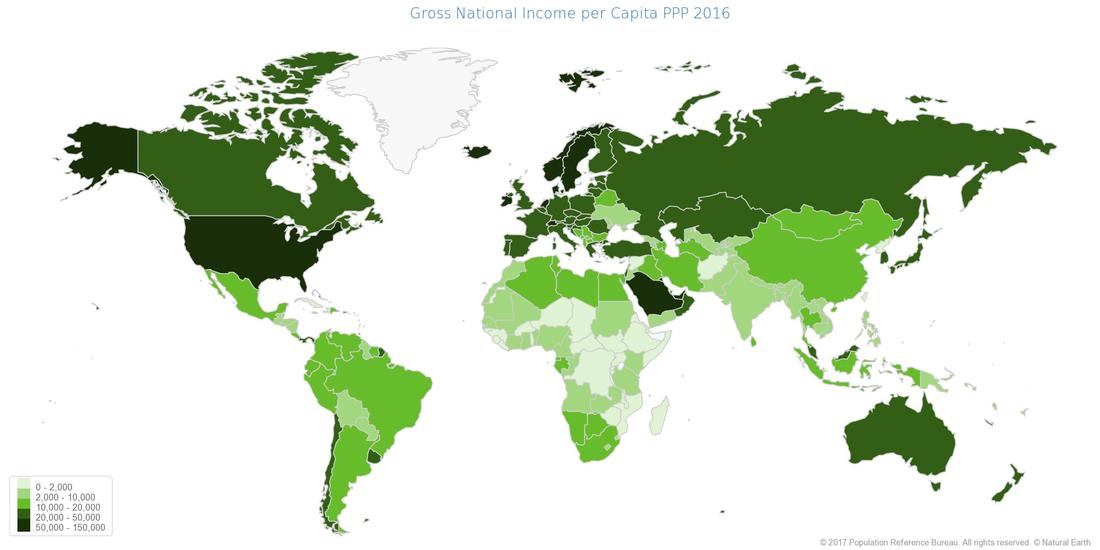
Click to enlarge each map
|
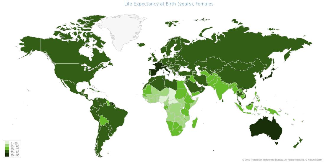
Click to enlarge each map
|
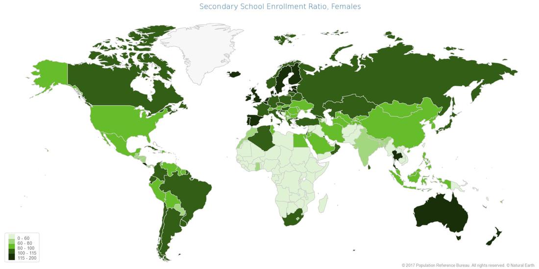
Click to enlarge each map
|
Task 1 - Use the worksheet below to complete all tasks as set out using the information in this section. You can view some maps above that show the distribution of each of the three developmental indicators that we will be using.
To access the most up to date information for both Niger and France, use the links below.
Literacy - click here
GDP per capita - click here
Life expectancy - click here
HDI Chart Link - Click here
To access the most up to date information for both Niger and France, use the links below.
Literacy - click here
GDP per capita - click here
Life expectancy - click here
HDI Chart Link - Click here
The second half of the worksheet above gives you examples of how inequalities exist within a country, i.e. France. However, the syllabus also states that you need to understand inequalities between countries. We have already studied this in our Population unit (Theme 1) when looking at the reasons why people move from Central and Southern America to the USA. You have the data set comparing Mexico & the USA. Please remember that you can use that case study to cover the knowledge required here.
Production Sectors
Objective: To be able to classify industries into primary, secondary and tertiary and be able to give illustrations of each.
Starter: Check out this PowerPoint!
Primary Sector: The exploitation of raw materials from the land, sea or air e.g. farming and mining.
Secondary Sector: The manufacturing of primary materials into finished products e.g. car building, food processing or construction.
Tertiary Sector: The providing of services to individuals and other businesses e.g. teaching, banking, retail and nursing.
Quaternary Sector: The generation and sharing of hi-tech knowledge e.g. medical research, Google glasses development or web page design.
Task 1 - Complete the 'Job Classification' task on the work booklet (below)
Employment Type & Development
Task 2 - Watch the video below from 18.00 to 21.45.
Task 3- Using the Industry work booklet, complete the graphing task (number 3) then plot on the location of each of the countries onto the worksheet below.
Task 4 - Complete the worksheet below by filling in the gaps using the words in the box.
What is Globalization?
|
|
|
Define Globalization:
Globalization is a process of interaction and integration among the people, companies, and governments of different nations, a process driven by international trade and investment and aided by information technology. This process has effects on the environment, on culture, on political systems, on economic development and prosperity, and on human physical well-being in societies around the world.
Globalization is a process of interaction and integration among the people, companies, and governments of different nations, a process driven by international trade and investment and aided by information technology. This process has effects on the environment, on culture, on political systems, on economic development and prosperity, and on human physical well-being in societies around the world.
|
|
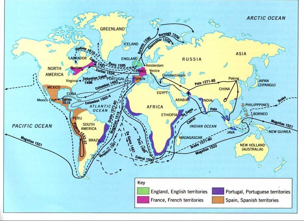
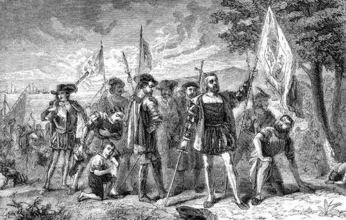
Task 1 - Use the two images (click to enlarge) above to explain the origins of the process of globalization. Make sure you make reference to the key character who is central in the artwork to the right.
Task 2 - Take a copy of the worksheet below and highlight the key aspects of the factors responsible for the modern day spread of globalization.
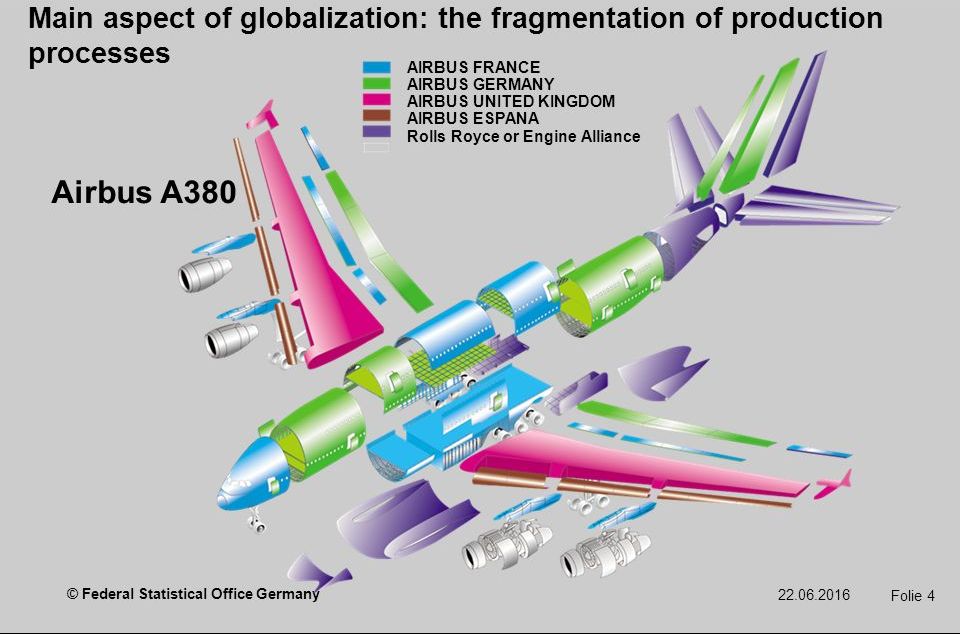
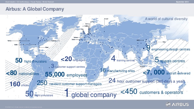
A TNC & its Global Links - Airbus
Task 3 - Click here to be taken to a a BBC Bitesize resource about the positive impacts of Globalization. Make a note of these on your worksheet. When complete, advance to page 5 of the BBC site and do the same for the negative impacts.
|
|
Task 4 - Study the diagram and map above. It shows where parts from an A380 aircraft come from and the operations of Airbus around the world. Now watch the video below.
Outline the following: What has been the role of technology in enabling Airbus to operate across the world?
a. What economic factors have contributed to their growth and spread?
b. What have the impacts at a local, national and global scale been?
Outline the following: What has been the role of technology in enabling Airbus to operate across the world?
a. What economic factors have contributed to their growth and spread?
b. What have the impacts at a local, national and global scale been?