
Fieldwork for submission in 2013
How do geomorphic processes affect the coast in Sitges, Spain?
(1200 words & 15% of your GCSE Grade)
Objective: To have an overview of what needs to be done for the geography fieldwork.
Background Research - Sitges, Spain.
Task 1 - The Location
Using Google Earth or Google Maps, locate Sitges. Make a note of its location. Where is it in Europe? Where is it within Spain (NESW, coastline). How far is it from Toulouse?
End Product - Map to show location with written description
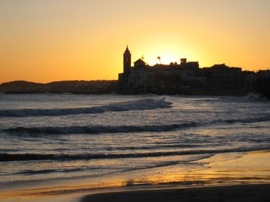
Task 2 - History of Sitges and other research
Carry out some research into the town. Find out about the original functions of Sitges and which particular alcoholic product it is famous for. Find out about the main sites and attractions and its beaches.
End Product - A4 fact sheet with the information above and some images to show main features.
Task 3 - The Virtual Visit
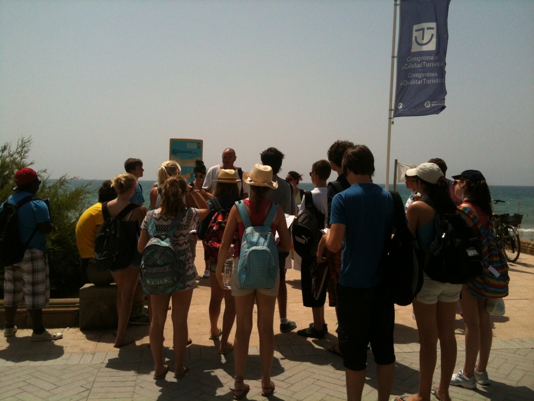
Study the Google Street View beneath. Take a tour along the promenade looking left (residential) and right (towards the beach). Describe what you see. What are some of the features that are visible on the beach and in the sea? You may need to do some further research to find out more ......
Interesting point - the house directly to your left is Russian owned and cost over €8 million!
End Product - Written description of physical and human characteristics of this coastline with some screen shots from Google Street View of interesting features.
Background Research - Sitges, Spain.
Task 1 - The Location
Using Google Earth or Google Maps, locate Sitges. Make a note of its location. Where is it in Europe? Where is it within Spain (NESW, coastline). How far is it from Toulouse?
End Product - Map to show location with written description
Task 2 - History of Sitges and other research
Carry out some research into the town. Find out about the original functions of Sitges and which particular alcoholic product it is famous for. Find out about the main sites and attractions and its beaches.
End Product - A4 fact sheet with the information above and some images to show main features.
Task 3 - The Virtual Visit
Study the Google Street View beneath. Take a tour along the promenade looking left (residential) and right (towards the beach). Describe what you see. What are some of the features that are visible on the beach and in the sea? You may need to do some further research to find out more ......
Interesting point - the house directly to your left is Russian owned and cost over €8 million!
End Product - Written description of physical and human characteristics of this coastline with some screen shots from Google Street View of interesting features.
1. What are geomorphic processes and how do they affect the coastline?
Objective: To find out how different rock types influence the features and levels of erosion that occur in coastal areas.
Background Research - Watch the video beneath. This is an old school video introduced by the very lovely Elliot Brown! It focuses on the United Kingdom, but the processes are the same in Sitges. Listen out for all the processes that he talks about relating to erosion, transportation and deposition. Make some notes.
Background Research - Watch the video beneath. This is an old school video introduced by the very lovely Elliot Brown! It focuses on the United Kingdom, but the processes are the same in Sitges. Listen out for all the processes that he talks about relating to erosion, transportation and deposition. Make some notes.
|
|
Key Words - Here are some of the key words that you heard in the video. Can you complete the definitions and explain how it works*?
1. Fetch ? 2. Cove ? 3. Hard Rock e.g.? 4. Soft Rock e.g.? 5. Erosion*? 6. Beach Sediment ? 7. Long Short Drift* ? 8. Spit ? 9. Groynes* ? 10. Beach Replenishment ? 11. Beach starvation*? 12. Rotational Cliff Slumping*? |
2. What the textbook saysTurn to page 32 - 33 of the OCR B Geography textbook. Make notes under the following headings please:
1. The Three Types of Marine Erosion a. Abrasion b. Hydraulic Pressure c. Attrition 2. Weathering in coastal areas a. Solution b. Wetting/drying c. Mass Movement 3. Impact of geology on coastal landforms 4. Copy the geology map into a Word document. Annotate any areas where you would expect rapid and gradual erosion to take place. Compare & Contrast! 5. Now look carefully at the Google Map below. Match up the areas that you identified as being vulnerable to rapid (fast) erosion. What do you notice? 6. Remember back to Elliot! How do people try to stop erosion and control long shore drift? What evidence can you see here of humans trying to control coastal processes in Sitges? Zoom in closer to get a better view. 7. Remember 'beach starvation'? Can you see an example here in Sitges (like in Barton-upon-Sea). Clue, long shore drift is going from north east to south west. |
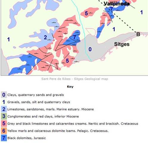
Thanks to the Barcelona Field Studies Centre.
|
Well Hard Rock ..........
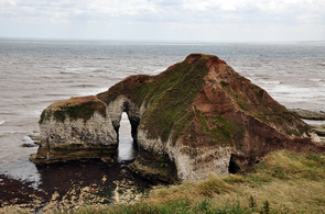
Objective: To find out about some hard rock features caused by erosion
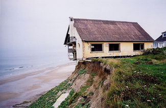
So, you remember about erosion, transportation and deposition? Erosion to the clay under Sitges is being slowed down by a number of different sea defences (groynes, rock islets) and the feature is a beach.
What happens when sea erodes away at hard rock then? You don't often find coastal protection in front of cliffs as they aren't worth protecting. Look at the picture to the right. Here is an example of a famous hard rock feature.
Background: Watch the two videos underneath. Try to 'get over' how cool the presenter man is....!
|
|
|
Task 1. Turn to page 34 of the OCR B textbook and make a sketch (skill) of figure 1.55 including the annotated labels.
Essential Resources
The documents underneath are vital to your fieldwork study. You already have a paper copy of the Fieldwork Booklet, but you will need to save a copy onto your computer and download the other documents underneath.
Low - Medium Control
You can do some of this at home
Part 1 - Setting the Scene (introduction)300 Words - Maximum - This involves
Part 2 - MethodologyWord Count - In table so doesn't count!
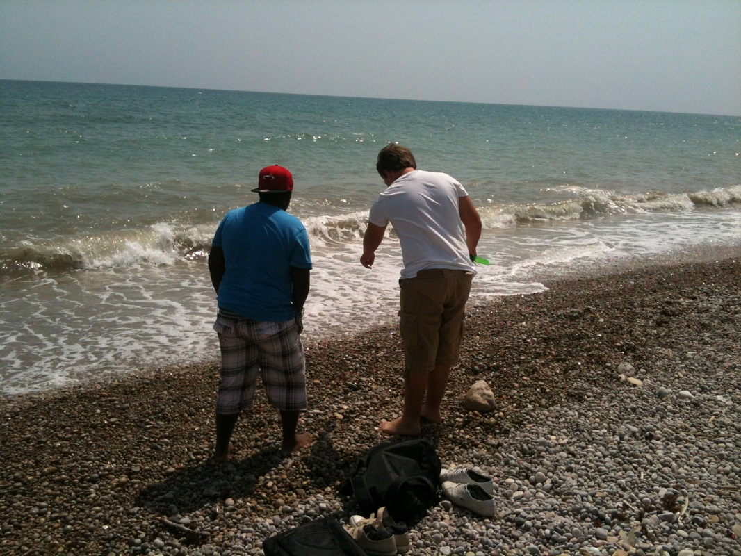
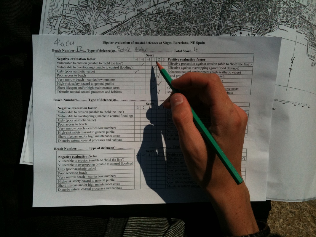
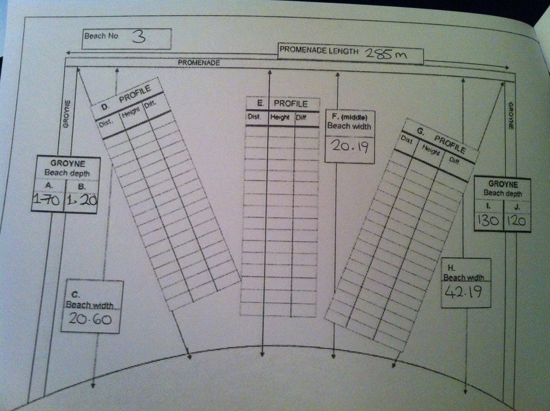
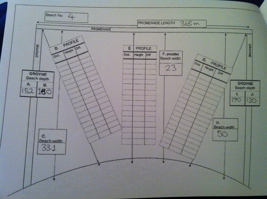
Aim: To write up our methodology. You are going to be writing up your methodology in table format. You must be precise and detailed in your descriptions to be able to access full marks on this section. Here are the methods that you employed in Sitges: 1. Beach profile (this splits into several parts) a. Width and gradient b. length c. depth from groyne to beach 2. Longshore drift data on the pebble beach 3. Bi-Polar analysis of sea defences 4. Field Sketches of unprotected beach past the nightclub. 5. Photos & other observations A list of equipment that you used can be found on the right hand side. It is important that you use the right names in the methodology. To avoid the tight word count, we are going to avoid this by putting the methodology into a table. Click on the button below to be taken to an example crib sheet. You may include some annotated photos on a separate page to show you carrying out the methods in the field (your photos) Part 3 - Data Presentation (graphs, photos, charts)You are going to need to present your data to enable you to effectively answer both of your research questions.
Research question 1 - How have geomorphic processes altered the coastline in Sitges? For this question you will need to present: 1. The geology map of Sitges 2. Your field sketch of the hard rock features beyond the nightclub. 3. Your erosion and wave attack information sheet 4. Longshore drift data sheet and plotting sheet from the pebble beach. Research Question 2 - How have people affected the geomorphic processes on this stretch of coastline? For this question you will need to present: 1. Beach profile data (needs to be collated by the class) and presented as a located bar chart. Data at the bottom of this page. 2. Bi Polar Analysis 3. Photos and other observations **No interpretation needed here, just clear and precise data presentation! 
|
Equipment used in Sitges field study – Sitges
Here is a list of the equipment that you used on the Sitges study. You need this information for your methodology. Beach profile measuring · Ranging Pole · Clinometer and support pole (with spike on) · Measuring Tape · Camera to take photos · Table in workbooklet to record data Coastal Defence · Camera · Bi Polar Evaluation technique · Assessment and Evaluation of coastal defences at Sitges Pebble measurement to determine LSD · Compass · Ruler · Recording table in booklet Field sketches · Pencils · Outline sketch sheet 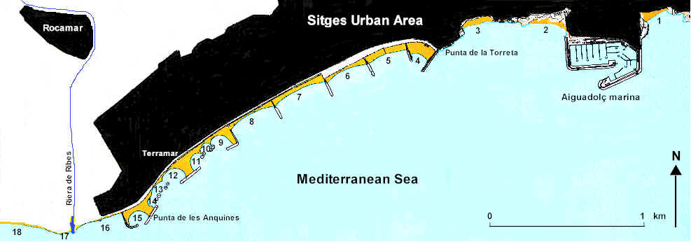

Images from Barcelona Field Studies Centre. Thanks to Derek Gearry.
|
How to do a located bar chart .... by Mr Podbury ..... and an annoying cat!


|

|
Zoom in slightly to create base for located bar chart - see video
High Control
This can only be done in your Geography lessons
Part 4 - Data InterpretationRQ 1 – How have geomorphic processes altered the coastline in Sitges?
Consider this…. Physical Dynamic stretch of coastline permeated by bands of resistant and less resistant rock. Fetch of up to 600km (coast of Sardinia). Frequency of fetch and direction of wave energy is predominately in two directions. Winter storms accelerate the levels of coastal erosion and sedimentary rocks such as limestone are more susceptible to corrasion. Sitges lies directly on top of soft clays and gravels and these are susceptible to faster and more dramatic rates of erosion and this was seen close to the location of the nightclub. Think about the two different types of coastline in Sitges and the associated features (hard rock & soft rock). Beaches and where the clay is found and just beyond the nightclub, there are hard rock features including wave cut notches, stumps and blow holes (plenty of photos). What causes these features? Link in to the different types of erosion. How and where does LSD take place? What do your measurement tell you from the pebble beach? Does this match up with the groyne depth measurements on beaches 1-5? |
RQ 2 - How have people affected the geomorphic processes on this stretch of coastline? Consider this .... Human Sitges has been referred to as the St. Tropez of Spain with property prices approaching those of the most expensive European cities, the main reason for this being the setting by the sea and the surrounding . Proximity to Barcelona International Airport is also a major advantage. Tourism numbers every year are large and hotels, shops, bars and restaurants are spread over the resort. The resort generates €millions every year in tourism and is well known as one of the largest gay resorts in Europe. Expensive property on the sea front such as the €8 million Russian mansion!! All this is worth protecting, especially when you have seen what geomorphic processes are at work in RQ1. What have humans done to alter the coastline? What types of protection have they put into place, where and why? How do these protection methods affect the geomorphic processes at work on this piece of coastline? You will need to study carefully your beach profile data sheet and bi-polar analysis as well as reading your Sitges coursework guide booklet (give before you left for Spain). |